Geolocate

Poitiers topographic map

Click on the map to display elevation.

About this map
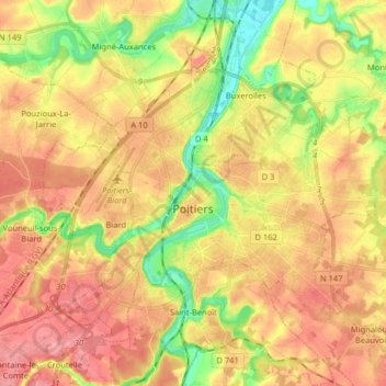
Name: Poitiers topographic map, elevation, terrain.

Location: Poitiers, Vienne, Nouvelle-Aquitaine, Metropolitan France, 86000, France (46.54223 0.29108 46.62701 0.45168)

Average elevation: 371 ft

Minimum elevation: 207 ft

Maximum elevation: 499 ft

Other topographic maps

Click on a map to view its topography, its elevation and its terrain.
La Chasseigne

France > Nouvelle-Aquitaine > Vienne > Thollet

Average elevation: 528 ft

Montin

France > Nouvelle-Aquitaine > Vienne > Vicq-sur-Gartempe

Average elevation: 325 ft

Les Bordes

France > Nouvelle-Aquitaine > Vienne > Gouex

Average elevation: 354 ft

Verrières

France > Nouvelle-Aquitaine > Vienne > Champniers

Average elevation: 449 ft

Gear up for your next adventure:

🛏️Cold Weather Sleeping Bag - Warm sleeping bag for cold conditions
🛡️Insect Repellent - Protection against bugs during outdoor activities
🥩Freeze-Dried Meals - Nutritious and lightweight food for remote expeditions
📌Outdoor GPS Map App - Apps and devices for digital topographic navigation
🎒Day Hiking Backpack - Lightweight backpack perfect for day trips and outdoor adventures

As an Amazon Associate, this site earns from qualifying purchases at no extra cost to you.