Geolocate

Huntsville topographic map

Click on the map to display elevation.

About this map

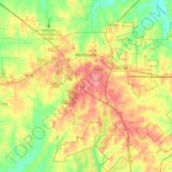
Name: Huntsville topographic map, elevation, terrain.

Location: Huntsville, Walker County, Texas, United States (30.60297 -95.64275 30.76895 -95.48761)

Average elevation: 354 ft

Minimum elevation: 217 ft

Maximum elevation: 509 ft

Walker County trails, hiking, mountain biking, running and outdoor activities

Other topographic maps

Click on a map to view its topography, its elevation and its terrain.

Dodge

United States > Texas > Walker County

Average elevation: 377 ft

Gear up for your next adventure:

📱Heavy-Duty Phone Cases - Drop-proof and waterproof protection for outdoor navigation
🎁Geography Themed Gifts - Unique gift ideas for map lovers and geography enthusiasts
🦶Carbon Trekking Poles - Reduce knee impact on steep descents with ultra-light poles
🎒Gear Packing Cubes - Organize your backpack efficiently
📦Gear Storage Bags - Organize and protect outdoor equipment

As an Amazon Associate, this site earns from qualifying purchases at no extra cost to you.