
Thank you for supporting this site ❤️
Make a donation
Make a donation
Gear up for your next adventure:
As an Amazon Associate, this site earns from qualifying purchases at no extra cost to you.
洋县 topographic map
Click on the map to display elevation.
Thank you for supporting this site ❤️
Make a donation
Make a donation
Gear up for your next adventure:
As an Amazon Associate, this site earns from qualifying purchases at no extra cost to you.
洋县
洋縣全境地势以山地丘陵为主。北部属秦岭南坡,一般海拔1000-2000米,昏人坪梁兴隆岭海拔3071米,为全县海拔最高点。中部属汉中盆地,海拔500米以下为沖積平原,地势低平;500-600米之间为波状地形。黄金峡镇白沙渡海拔389米,为全县海拔最低点。南部为花岗岩丘陵,海拔600-800米。
Thank you for supporting this site ❤️
Make a donation
Make a donation
Gear up for your next adventure:
As an Amazon Associate, this site earns from qualifying purchases at no extra cost to you.
About this map
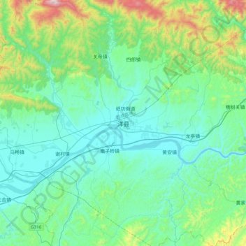
Name: 洋县 topographic map, elevation, terrain.
Location: 洋县, 洋州街道, 洋县, 汉中市, 陕西省, 中国 (33.06747 107.38074 33.38747 107.70074)
Average elevation: 2,142 ft
Minimum elevation: 1,447 ft
Maximum elevation: 5,213 ft
Thank you for supporting this site ❤️
Make a donation
Make a donation
Gear up for your next adventure:
As an Amazon Associate, this site earns from qualifying purchases at no extra cost to you.