
Make a donation
Gear up for your next adventure:
As an Amazon Associate, this site earns from qualifying purchases at no extra cost to you.
Riederalp topographic map
Click on the map to display elevation.
Make a donation
Gear up for your next adventure:
As an Amazon Associate, this site earns from qualifying purchases at no extra cost to you.
Riederalp
The mid-mountain resort sits on a south-facing terrace, south of the 23 km (14 mi) long Aletsch Glacier—Europe's largest, in the Bernese Alps. The altitude of the village (1,930 m [6,330 ft]) allows good view of the Pennine Alps with some of its highest summits such as the Fletschhorn, Dom and Matterhorn.
Make a donation
Gear up for your next adventure:
As an Amazon Associate, this site earns from qualifying purchases at no extra cost to you.
About this map
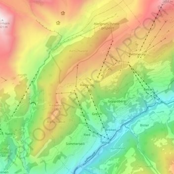
Name: Riederalp topographic map, elevation, terrain.
Location: Riederalp, Östlich Raron, Wallis, Switzerland (46.34239 8.00188 46.41219 8.06463)
Average elevation: 5,531 ft
Minimum elevation: 2,336 ft
Maximum elevation: 9,849 ft
Make a donation
Gear up for your next adventure:
As an Amazon Associate, this site earns from qualifying purchases at no extra cost to you.