Geolocate

Gaggenau topographic map

Click on the map to display elevation.

About this map
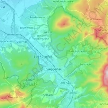
Name: Gaggenau topographic map, elevation, terrain.

Location: Gaggenau, Landkreis Rastatt, Baden-Württemberg, 76571, Germany (48.76934 8.28499 48.86263 8.41736)

Average elevation: 843 ft

Minimum elevation: 377 ft

Maximum elevation: 2,356 ft

Other topographic maps

Click on a map to view its topography, its elevation and its terrain.
Hörden

Germany > Baden-Württemberg > Landkreis Rastatt > Gaggenau

Average elevation: 705 ft

Gear up for your next adventure:

🦟Ultrasonic Repellers - Create a bug-free zone at your camp or rest stop
🦺Reflective Outdoor Gear - Safety gear for low‑light conditions
🪶Paracord Bracelet - Survival bracelet with built‑in tools
🌎3D Topographic Globes - Raised relief globes for a tactile understanding of geography
🧺Microfiber Travel Towels - Compact and fast-drying towels for trail use

As an Amazon Associate, this site earns from qualifying purchases at no extra cost to you.