Geolocate

Mabinay topographic map

Click on the map to display elevation.

About this map

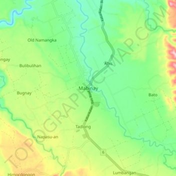
Name: Mabinay topographic map, elevation, terrain.

Location: Mabinay, Negros Oriental, Central Visayas, 6207, Philippines (9.68655 122.88949 9.76655 122.96949)

Average elevation: 479 ft

Minimum elevation: 164 ft

Maximum elevation: 1,056 ft

Other topographic maps

Click on a map to view its topography, its elevation and its terrain.

Cantil-e

Philippines > Negros Oriental > Dumaguete

Average elevation: 253 ft

La Paz

Philippines > Negros Oriental > Bais

Average elevation: 49 ft

Sibulan

Philippines > Negros Oriental

Average elevation: 712 ft

Lake Balinsasayao

Philippines > Negros Oriental > Sibulan

Average elevation: 3,169 ft

Gear up for your next adventure:

🚪Portable Camp Chair - Foldable chair for comfort at camp
🧥Waterproof Jacket for Hiking - Breathable and rugged rain jacket for outdoor excursions
Camping Coffee Makers - Enjoy premium coffee at the summit or campsite
🦟Ultrasonic Repellers - Create a bug-free zone at your camp or rest stop
⛑️Personal Locator Beacon - Safety beacon for emergencies

As an Amazon Associate, this site earns from qualifying purchases at no extra cost to you.