
Make a donation
Gear up for your next adventure:
As an Amazon Associate, this site earns from qualifying purchases at no extra cost to you.
Boa Vista topographic map
Click on the map to display elevation.
Make a donation
Gear up for your next adventure:
As an Amazon Associate, this site earns from qualifying purchases at no extra cost to you.
About this map
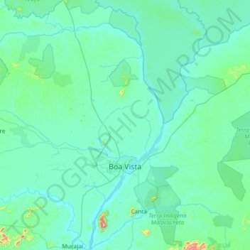
Name: Boa Vista topographic map, elevation, terrain.
Average elevation: 318 ft
Minimum elevation: 180 ft
Maximum elevation: 2,815 ft
Make a donation
Gear up for your next adventure:
As an Amazon Associate, this site earns from qualifying purchases at no extra cost to you.
Other topographic maps
Click on a map to view its topography, its elevation and its terrain.
Wei-Assipu-tepui
Wei-Assipu-tepui has a maximum elevation of around 2,400 metres (7,870 ft). Its summit plateau is highly dissected and generally inclined south-southwest (towards the Brazilian side). The rocky summit is partially forested, with flowering plants of the genus Bonnetia featuring prominently. It also hosts a…
Average elevation: 5,774 ft
Make a donation
Gear up for your next adventure:
As an Amazon Associate, this site earns from qualifying purchases at no extra cost to you.