Geolocate

Teignmouth topographic map

Click on the map to display elevation.

About this map

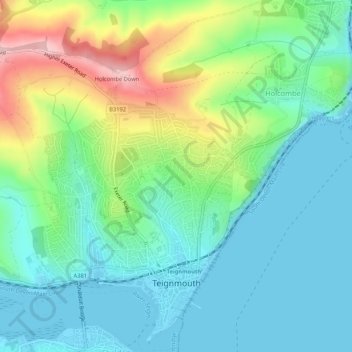
Name: Teignmouth topographic map, elevation, terrain.

Location: Teignmouth, Teignbridge, Devon, England, United Kingdom (50.53973 -3.52264 50.57335 -3.48075)

Average elevation: 194 ft

Minimum elevation: -3 ft

Maximum elevation: 689 ft

Other topographic maps

Click on a map to view its topography, its elevation and its terrain.

Water

United Kingdom > England > Devon > Teignbridge

Average elevation: 856 ft

Higher Ashton

United Kingdom > England > Devon > Teignbridge

Average elevation: 381 ft

Bovey Tracey

United Kingdom > England > Devon > Teignbridge

Average elevation: 358 ft

Gear up for your next adventure:

🔌Solar Panel Charger - Charge gear sustainably outdoors
🧭Pro Hiking Compasses - High-accuracy liquid-filled compasses for topographic orientation
📦Gear Storage Bags - Organize and protect outdoor equipment
🗺️Topographic Maps - Detailed topo maps for hiking, exploring and outdoor navigation
🪶Paracord Bracelet - Survival bracelet with built‑in tools

As an Amazon Associate, this site earns from qualifying purchases at no extra cost to you.