Geolocate

Culiacán topographic map

Click on the map to display elevation.

Culiacán

Culiacán is located in the central region of the State of Sinaloa, forming part of the Northwest of Mexico. The coordinates that correspond to it are 24 ° 48'15 "N (latitude) by 107 ° 25'52" W (West), with an altitude of 54 meters above sea level.

Wikipedia (CC-BY-SA 3.0)

About this map

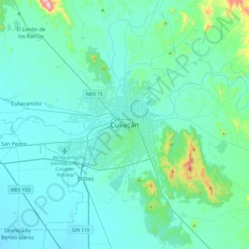
Name: Culiacán topographic map, elevation, terrain.

Location: Culiacán, Culiacán Rosales, Culiacán, Sinaloa, 80220, Mexico (24.63790 -107.55340 24.95790 -107.23340)

Average elevation: 279 ft

Minimum elevation: 20 ft

Maximum elevation: 2,507 ft

Other topographic maps

Click on a map to view its topography, its elevation and its terrain.

Parque Nuevo Culican

Mexico > Sinaloa > Culiacán > Culiacán

Average elevation: 210 ft

Maralago

Mexico > Sinaloa > Culiacán > Culiacán Rosales

Average elevation: 223 ft

Amapas

Mexico > Sinaloa > Culiacán > Culiacán Rosales

Average elevation: 164 ft

Gear up for your next adventure:

🗻Climbing Gear Basics - Essential gear for beginner climbers
🩹Survival Bandages - High‑quality bandages for emergencies
🔪Outdoor Multitools - Essential survival tools for gear repair and field use
🦺Reflective Outdoor Gear - Safety gear for low‑light conditions
👟Men's Trail Runners - Lightweight footwear for fast-paced exploration and light hiking

As an Amazon Associate, this site earns from qualifying purchases at no extra cost to you.