
Thank you for supporting this site ❤️
Make a donation
Make a donation
Gear up for your next adventure:
As an Amazon Associate, this site earns from qualifying purchases at no extra cost to you.
Tarecuato topographic map
Click on the map to display elevation.
Thank you for supporting this site ❤️
Make a donation
Make a donation
Gear up for your next adventure:
As an Amazon Associate, this site earns from qualifying purchases at no extra cost to you.
About this map
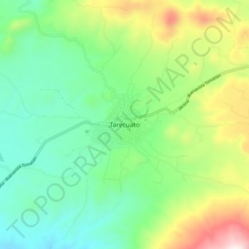
Name: Tarecuato topographic map, elevation, terrain.
Location: Tarecuato, Tangamandapio, Michoacán, Mexico (19.80352 -102.50466 19.88352 -102.42466)
Average elevation: 6,693 ft
Minimum elevation: 5,699 ft
Maximum elevation: 8,832 ft
Thank you for supporting this site ❤️
Make a donation
Make a donation
Gear up for your next adventure:
As an Amazon Associate, this site earns from qualifying purchases at no extra cost to you.