Geolocate

Quebrada Verde topographic map

Click on the map to display elevation.

About this map

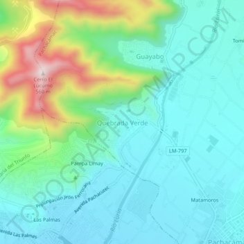
Name: Quebrada Verde topographic map, elevation, terrain.

Location: Quebrada Verde, Lima Metropolitan Area, Lima, 15088, Peru (-12.23025 -76.89724 -12.19025 -76.85724)

Average elevation: 568 ft

Minimum elevation: 154 ft

Maximum elevation: 1,877 ft

Other topographic maps

Click on a map to view its topography, its elevation and its terrain.

San Juan de Lurigancho

Peru > Lima > Lima Metropolitan Area

Average elevation: 1,775 ft

La Molina

Peru > Lima > Lima Metropolitan Area

Average elevation: 1,453 ft

D

Peru > Lima > Lima Metropolitan Area

Average elevation: 184 ft

Gear up for your next adventure:

🪶Survival Guide Book - Expert advice for emergency preparedness
🌄Hiking Binoculars - Compact binoculars for scenic views and trail spotting
👖Convertible Hiking Pants - Versatile zip-off pants for changing altitudes and temperatures
📡GPS Antenna Upgrade - Enhance GPS reception in remote terrain
🦶Carbon Trekking Poles - Reduce knee impact on steep descents with ultra-light poles

As an Amazon Associate, this site earns from qualifying purchases at no extra cost to you.