Geolocate

Poway topographic map

Click on the map to display elevation.

About this map

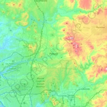
Name: Poway topographic map, elevation, terrain.

Location: Poway, San Diego County, California, 92064, United States (32.80282 -117.19586 33.12282 -116.87586)

Average elevation: 791 ft

Minimum elevation: 10 ft

Maximum elevation: 2,946 ft

San Diego County trails, hiking, mountain biking, running and outdoor activities

Gear up for your next adventure:

🏥Hiking First Aid Kits - Comprehensive medical kits for remote trail injuries
🧥Men's Rain Shells - Premium waterproof and breathable jackets for mountain weather
🧯Emergency Survival Kit - All‑in‑one survival essentials for the backcountry
🌄Hiking Binoculars - Compact binoculars for scenic views and trail spotting
🛰️Satellite Messengers - Emergency SOS and two-way messaging for off-grid adventures

As an Amazon Associate, this site earns from qualifying purchases at no extra cost to you.