
Vila do Conde topographic map
Interactive map
Click on the map to display elevation.
About this map
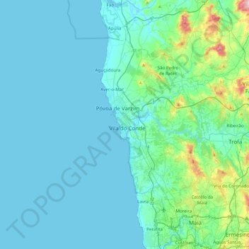
Name: Vila do Conde topographic map, elevation, terrain.
Location: Vila do Conde, Porto, 4480-673 VILA DO CONDE, Portugal (41.19810 -8.90756 41.51810 -8.58756)
Average elevation: 128 ft
Minimum elevation: -10 ft
Maximum elevation: 1,129 ft
Other topographic maps
Click on a map to view its topography, its elevation and its terrain.
Junqueira
Portugal > Porto > Vila do Conde
Junqueira, Vila do Conde, Porto, Portugal
Average elevation: 197 ft
Tougues
Portugal > Porto > Vila do Conde
Tougues, Vila do Conde, Porto, 4480-105, Portugal
Average elevation: 121 ft