
Nijlande topographic map
Interactive map
Click on the map to display elevation.
About this map
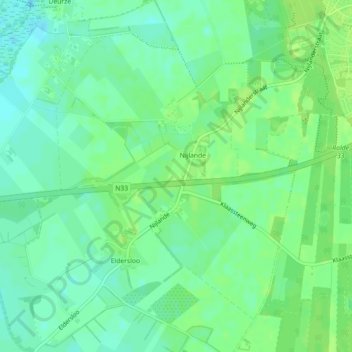
Name: Nijlande topographic map, elevation, terrain.
Location: Nijlande, Aa en Hunze, Drenthe, Nederland (52.96056 6.60896 52.98249 6.63972)
Average elevation: 49 ft
Minimum elevation: 26 ft
Maximum elevation: 66 ft
Other topographic maps
Click on a map to view its topography, its elevation and its terrain.
Nooitgedacht
Nederland > Drenthe > Aa en Hunze
Nooitgedacht, Aa en Hunze, Drenthe, Nederland
Average elevation: 49 ft
Annerveenschekanaal
Nederland > Drenthe > Aa en Hunze
Annerveenschekanaal, Aa en Hunze, Drenthe, Nederland
Average elevation: 7 ft
Gieterveen
Nederland > Drenthe > Aa en Hunze > Gieterveen
Gieterveen, Aa en Hunze, Drenthe, Nederland, 9511, Nederland
Average elevation: 13 ft
Bareveld
Nederland > Drenthe > Aa en Hunze > Bareveld
Bareveld, Aa en Hunze, Drenthe, Nederland, 9512, Nederland
Average elevation: 13 ft
Vredenheim
Nederland > Drenthe > Aa en Hunze
Vredenheim, Aa en Hunze, Drenthe, Nederland
Average elevation: 52 ft