
Roanoke (city) topographic map
Interactive map
Click on the map to display elevation.
About this map
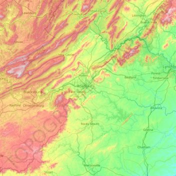
Name: Roanoke (city) topographic map, elevation, terrain.
Location: Roanoke (city), Virginia, 24013, United States of America (36.61292 -80.54938 37.89292 -79.26938)
Average elevation: 1,585 ft
Minimum elevation: 344 ft
Maximum elevation: 4,301 ft
Other topographic maps
Click on a map to view its topography, its elevation and its terrain.
Staunton
United States of America > Virginia > Staunton > Staunton City
Staunton, Waynesboro (city), Virginia, 24401, United States of America
Average elevation: 1,522 ft
Norfolk
United States of America > Virginia > Norfolk
Norfolk, Virginia, 23510, United States of America
Average elevation: 13 ft
Chincoteague Island
United States of America > Virginia > Chincoteague
Chincoteague Island, Chincoteague, Accomack County, Virginia, 2336, United States of America
Average elevation: 7 ft
Poquoson
United States of America > Virginia > Poquoson
Poquoson, Poquoson City, Virginia, 23662, United States of America
Average elevation: 7 ft
Alexandria
United States of America > Virginia > Alexandria
Alexandria, Virginia, 22314, United States of America
Average elevation: 174 ft
Chesterfield
United States of America > Virginia > Chesterfield
Chesterfield, Chesterfield County, Virginia, United States of America
Average elevation: 187 ft
Lexington
United States of America > Virginia
Lexington, Virginia, United States of America
Average elevation: 1,086 ft
Rotary Park
United States of America > Virginia > Leesburg
Rotary Park, Leesburg, Loudoun County, Virginia, United States of America
Average elevation: 341 ft
Blue Ridge Lake
United States of America > Virginia > Saint George
Blue Ridge Lake, Mayo Drive, Saint George, Greene County, Virginia, 22973, United States of America
Average elevation: 945 ft
Monterey
United States of America > Virginia > Monterey
Monterey, Virginia, 24465, United States of America
Average elevation: 3,022 ft
Oakland
United States of America > Virginia > Oakland
Oakland, Suffolk (city), Virginia, 23432, United States of America
Average elevation: 49 ft
Garrisonville
United States of America > Virginia > Garrisonville
Garrisonville, Stafford County, Virginia, 22463, United States of America
Average elevation: 210 ft
Virginia Heights
United States of America > Virginia > Virginia Heights
Virginia Heights, Henrico County, Virginia, 23250, United States of America
Average elevation: 161 ft
Narrow Back Mountain
United States of America > Virginia
Narrow Back Mountain, Rockingham County, Virginia, United States of America
Average elevation: 1,854 ft
Mulberry Greens
United States of America > Virginia > Culpeper > Mulberry Greens
Mulberry Greens, Culpeper, Culpeper County, Virginia, 22701, United States of America
Average elevation: 443 ft
Penn Laird
United States of America > Virginia > Harrisonburg > Penn Laird
Penn Laird, Harrisonburg, Rockingham County, Virginia, 22846, United States of America
Average elevation: 1,365 ft
Buffalo Forge
United States of America > Virginia > Buffalo Forge
Buffalo Forge, Rockbridge County, Virginia, United States of America
Average elevation: 938 ft
Mount Pleasant
United States of America > Virginia > Chesapeake > Mount Pleasant
Mount Pleasant, Chesapeake, Virginia, United States of America
Average elevation: 13 ft
Steeple Chase
United States of America > Virginia > Steeple Chase
Steeple Chase, James City County, Virginia, 23186, United States of America
Average elevation: 69 ft
Northwest
United States of America > Virginia > Chesapeake > Northwest
Northwest, Chesapeake, Virginia Beach (city), Virginia, United States of America
Average elevation: 10 ft
High Top
United States of America > Virginia
High Top, Bath County, Virginia, United States of America
Average elevation: 3,097 ft
River Park
United States of America > Virginia > River Park
River Park, Clarke County, Virginia, United States of America
Average elevation: 571 ft
Kings Crossroads
United States of America > Virginia > Kings Crossroads
Kings Crossroads, Prince William County, Virginia, United States of America
Average elevation: 253 ft
Drewrys Bluff
United States of America > Virginia
Drewrys Bluff, Richmond-Petersburg Turnpike, Bellwood, Chesterfield County, Virginia, 23237, United States of America
Average elevation: 59 ft
Deerfield
United States of America > Virginia > Deerfield
Deerfield, Prince William County, Virginia, 20111:20112, United States of America
Average elevation: 259 ft
Ashley Woods
United States of America > Virginia > Chesapeake > Ashley Woods
Ashley Woods, Chesapeake, Virginia, 23320, United States of America
Average elevation: 30 ft
Criders
United States of America > Virginia > Harrisonburg > Criders
Criders, Harrisonburg, Rockingham County, Virginia, 22820, United States of America
Average elevation: 1,860 ft
Pound
United States of America > Virginia > Pound
Pound, Wise County, Virginia, United States of America
Average elevation: 1,739 ft
Malibu
United States of America > Virginia > Malibu
Malibu, Virginia Beach (city), Virginia, 23452, United States of America
Average elevation: 16 ft
Egypt Bend Estates
United States of America > Virginia > Egypt Bend Estates
Egypt Bend Estates, Page County, Virginia, 22835, United States of America
Average elevation: 860 ft
Reston
United States of America > Virginia > Reston
Reston, Fairfax County, Virginia, United States of America
Average elevation: 364 ft
Cedar Point
United States of America > Virginia > Cedar Point
Cedar Point, Suffolk (city), Virginia, 23433, United States of America
Average elevation: 10 ft
Thornecrest
United States of America > Virginia > Thornecrest
Thornecrest, Roanoke County, Virginia, 24017, United States of America
Average elevation: 1,161 ft
Inman
United States of America > Virginia > Appalachia > Inman
Inman, Appalachia, Wise County, Virginia, 24216, United States of America
Average elevation: 1,995 ft
Benefit
United States of America > Virginia > Chesapeake > Benefit
Benefit, Chesapeake, Virginia, United States of America
Average elevation: 13 ft
Jumping Branch
United States of America > Virginia
Jumping Branch, Campbell County, Virginia, 24554:24588, United States of America
Average elevation: 791 ft
Broadmoor
United States of America > Virginia > Chesapeake > Broadmoor
Broadmoor, Chesapeake, Virginia, 23323, United States of America
Average elevation: 13 ft
Great Neck Manor
United States of America > Virginia > Great Neck Manor
Great Neck Manor, Virginia Beach (city), Virginia, 23451, United States of America
Average elevation: 16 ft
The Lakes
United States of America > Virginia > The Lakes
The Lakes, Virginia Beach (city), Virginia, 23453, United States of America
Average elevation: 16 ft
Yadkin
United States of America > Virginia > Chesapeake > Yadkin
Yadkin, Chesapeake, Virginia, 23323, United States of America
Average elevation: 20 ft
Lakeview Park
United States of America > Virginia > Norfolk > Lakeview Park
Lakeview Park, Norfolk, Virginia Beach (city), Virginia, 23455, United States of America
Average elevation: 23 ft
Manning
United States of America > Virginia > Manning
Manning, Suffolk (city), Virginia, United States of America
Average elevation: 62 ft
Parkview
United States of America > Virginia > Chesapeake > Parkview
Parkview, Chesapeake, Virginia, 23323, United States of America
Average elevation: 10 ft
Saunders
United States of America > Virginia > Saunders
Saunders, Suffolk (city), Virginia, United States of America
Average elevation: 46 ft
Lake Prince
United States of America > Virginia > Lake Prince Meadows
Lake Prince, Sandy Point Lane, Lake Prince Meadows, Isle of Wight County, Virginia, 23487, United States of America
Average elevation: 62 ft
Rivercliff
United States of America > Virginia > Rivercliff
Rivercliff, Suffolk (city), Virginia, 23432, United States of America
Average elevation: 10 ft
Sandy Bottom
United States of America > Virginia > Sandy Bottom
Sandy Bottom, Suffolk (city), Virginia, 23432, United States of America
Average elevation: 16 ft
Berwyn
United States of America > Virginia > Berwyn
Berwyn, Suffolk (city), Virginia, 23435, United States of America
Average elevation: 16 ft
Saint Brides
United States of America > Virginia > Chesapeake > Saint Brides
Saint Brides, Chesapeake, Virginia, 23328-6482, United States of America
Average elevation: 13 ft
North Lakes
United States of America > Virginia > North Lakes
North Lakes, Roanoke County, Virginia, 24017, United States of America
Average elevation: 1,194 ft