
Barrancas del Cobre topographic map
Interactive map
Click on the map to display elevation.
About this map
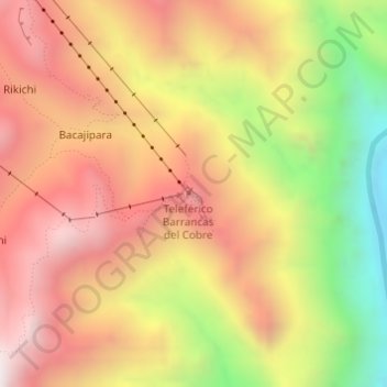
Name: Barrancas del Cobre topographic map, elevation, terrain.
Average elevation: 5,312 ft
Minimum elevation: 3,028 ft
Maximum elevation: 6,991 ft
Other topographic maps
Click on a map to view its topography, its elevation and its terrain.
Parque de aventura Barrancas del cobre
Parque de aventura Barrancas del cobre, Urique, Chihuahua, México
Average elevation: 6,732 ft
San Rafael
San Rafael, Urique, Chihuahua, México
Average elevation: 7,228 ft