
Provincia de Padre Abad topographic map
Interactive map
Click on the map to display elevation.
About this map
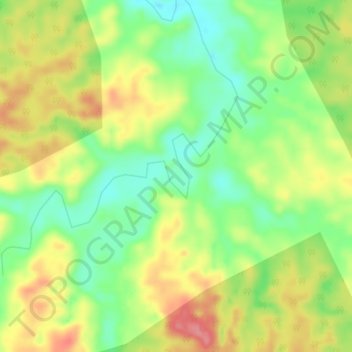
Name: Provincia de Padre Abad topographic map, elevation, terrain.
Location: Provincia de Padre Abad, Padre Abad, Ucayali, Perú (-8.82770 -75.40619 -8.78770 -75.36619)
Average elevation: 883 ft
Minimum elevation: 748 ft
Maximum elevation: 1,033 ft
Other topographic maps
Click on a map to view its topography, its elevation and its terrain.
Pampa Yurac
Perú > Ucayali > Padre Abad
Pampa Yurac, Padre Abad, Ucayali, Perú
Average elevation: 1,240 ft
Aguaytía
Perú > Ucayali > Padre Abad > Aguaytía
Aguaytía, Padre Abad, Provincia de Padre Abad, Ucayali, Perú
Average elevation: 1,024 ft
Previsto
Perú > Ucayali > Padre Abad > Previsto
Previsto, Padre Abad, Provincia de Padre Abad, Ucayali, Perú
Average elevation: 3,100 ft