
Malubog Dam topographic map
Interactive map
Click on the map to display elevation.
About this map
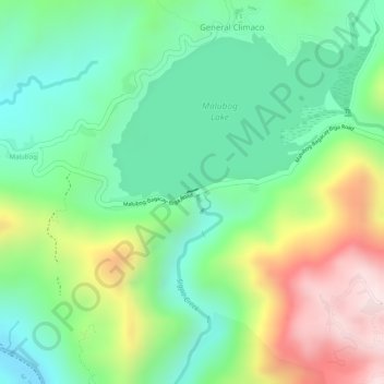
Name: Malubog Dam topographic map, elevation, terrain.
Location: Malubog Dam, Toledo, Cebu, Central Visayas, Philippines (10.36147 123.71379 10.36197 123.71490)
Average elevation: 728 ft
Minimum elevation: 154 ft
Maximum elevation: 1,667 ft
Other topographic maps
Click on a map to view its topography, its elevation and its terrain.
Toledo City Plaza
Philippines > Cebu > Toledo
Toledo City Plaza, Toledo, Cebu, Central Visayas, 6038, Philippines
Average elevation: 30 ft
Toledo Port
Philippines > Cebu > Toledo
Toledo Port, Toledo, Cebu, Central Visayas, 6038, Philippines
Average elevation: 20 ft