
Make a donation
Gear up for your next adventure:
As an Amazon Associate, this site earns from qualifying purchases at no extra cost to you.
Simojovel topographic map
Click on the map to display elevation.
Make a donation
Gear up for your next adventure:
As an Amazon Associate, this site earns from qualifying purchases at no extra cost to you.
About this map
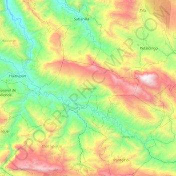
Name: Simojovel topographic map, elevation, terrain.
Location: Simojovel, Chiapas, Mexico (17.06794 -92.79751 17.22593 -92.43459)
Average elevation: 3,192 ft
Minimum elevation: 413 ft
Maximum elevation: 8,064 ft
Make a donation
Gear up for your next adventure:
As an Amazon Associate, this site earns from qualifying purchases at no extra cost to you.
Other topographic maps
Click on a map to view its topography, its elevation and its terrain.
Palenque
The municipality borders the municipalities of Catazajá, La Libertad, Ocosingo, Chilán and Salto de Agua. It also borders the state of Tabasco and Guatemala to the east. Aside from the municipal seat, other important communities include Río Chancala, Bajadas Grandes. Agua Blanca Serranía, Dr. Samuel León…
Average elevation: 253 ft
Make a donation
Gear up for your next adventure:
As an Amazon Associate, this site earns from qualifying purchases at no extra cost to you.
Make a donation
Gear up for your next adventure:
As an Amazon Associate, this site earns from qualifying purchases at no extra cost to you.