
Korthikota topographic map
Interactive map
Click on the map to display elevation.
About this map
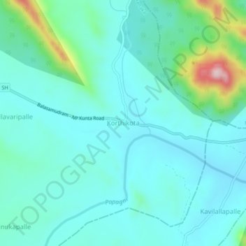
Name: Korthikota topographic map, elevation, terrain.
Location: Korthikota, Tanakal, Sri Sathya Sai, Andhra Pradesh, India (13.91562 78.30263 13.95562 78.34263)
Average elevation: 1,703 ft
Minimum elevation: 1,516 ft
Maximum elevation: 2,559 ft
Other topographic maps
Click on a map to view its topography, its elevation and its terrain.
Ethodu
India > Andhra Pradesh > Tanakal
Ethodu, Tanakal, Sri Sathya Sai, Andhra Pradesh, India
Average elevation: 2,028 ft