
Make a donation
Gear up for your next adventure:
As an Amazon Associate, this site earns from qualifying purchases at no extra cost to you.
Bento Gonçalves topographic map
Click on the map to display elevation.
Make a donation
Gear up for your next adventure:
As an Amazon Associate, this site earns from qualifying purchases at no extra cost to you.
Bento Gonçalves
The average elevation of Bento Gonçalves is 690 meters above the sea level. Summers are warm and winters are mild. During the climatic winter frosts are common and snow is rare. The highest temperature officially recorded in the city was 36 °C and the lowest was -4,5 °C.
Make a donation
Gear up for your next adventure:
As an Amazon Associate, this site earns from qualifying purchases at no extra cost to you.
About this map
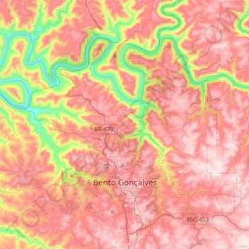
Name: Bento Gonçalves topographic map, elevation, terrain.
Average elevation: 1,604 ft
Minimum elevation: 226 ft
Maximum elevation: 2,510 ft
Make a donation
Gear up for your next adventure:
As an Amazon Associate, this site earns from qualifying purchases at no extra cost to you.
Other topographic maps
Click on a map to view its topography, its elevation and its terrain.
Quarto Frio
Brazil > Rio Grande do Sul > Metropolitan Region of Porto Alegre > Taquara
Average elevation: 866 ft
Taquaruçu
Brazil > Rio Grande do Sul > Aglomeração Urbana do Litoral Norte > Mampituba
Average elevation: 709 ft
Make a donation
Gear up for your next adventure:
As an Amazon Associate, this site earns from qualifying purchases at no extra cost to you.
Make a donation
Gear up for your next adventure:
As an Amazon Associate, this site earns from qualifying purchases at no extra cost to you.
Pelotas
Brazil > Rio Grande do Sul > Aglomeração Urbana do Sul > Pelotas
As it is situated on a plain near the ocean, the urban area lies on a low elevation, being, on average, 7 meters (23 ft) above sea level. The interior of the municipality is on a plateau called Serras de Sudeste (Southeastern Mountain Ranges). Consequently, the altitude in Pelotas' rural area reaches 429…
Average elevation: 59 ft
Praça
Brazil > Rio Grande do Sul > Metropolitan Region of Porto Alegre > Porto Alegre
Average elevation: 49 ft
Make a donation
Gear up for your next adventure:
As an Amazon Associate, this site earns from qualifying purchases at no extra cost to you.