Geolocate

Strepeis topographic map

Click on the map to display elevation.

About this map

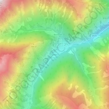
Name: Strepeis topographic map, elevation, terrain.

Location: Strepeis, Bagni di Vinadio, Vinadio, Cuneo, Piedmont, Italy (44.26544 7.04997 44.30544 7.08997)

Average elevation: 5,768 ft

Minimum elevation: 3,743 ft

Maximum elevation: 8,451 ft

Gear up for your next adventure:

🪶Thermal Camp Blanket - Extra warmth for cold nights
🛌Ultralight Sleeping Bags - Compact down bags for cold nights in the wilderness
📌Outdoor GPS Map App - Apps and devices for digital topographic navigation
🎒Trail Energy Bars - High‑calorie bars for hiking energy
🔭Telescopic Hiking Pole - Adjustable pole for hiking stability

As an Amazon Associate, this site earns from qualifying purchases at no extra cost to you.