
Make a donation
Gear up for your next adventure:
As an Amazon Associate, this site earns from qualifying purchases at no extra cost to you.
Tirur topographic map
Click on the map to display elevation.
Make a donation
Gear up for your next adventure:
As an Amazon Associate, this site earns from qualifying purchases at no extra cost to you.
Tirur
Tirur is a major trading centre for electronic devices and seafood in Northern Kerala and has an average elevation of 2 metres (6 ft 7 in) above the sea level.
Make a donation
Gear up for your next adventure:
As an Amazon Associate, this site earns from qualifying purchases at no extra cost to you.
About this map
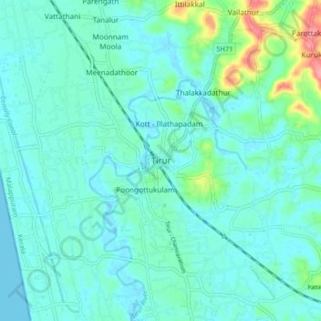
Name: Tirur topographic map, elevation, terrain.
Location: Tirur, Malappuram, Kerala, 676101, India (10.87668 75.88399 10.95668 75.96399)
Average elevation: 49 ft
Minimum elevation: -7 ft
Maximum elevation: 289 ft
Make a donation
Gear up for your next adventure:
As an Amazon Associate, this site earns from qualifying purchases at no extra cost to you.
Other topographic maps
Click on a map to view its topography, its elevation and its terrain.
Make a donation
Gear up for your next adventure:
As an Amazon Associate, this site earns from qualifying purchases at no extra cost to you.