
Make a donation
Gear up for your next adventure:
As an Amazon Associate, this site earns from qualifying purchases at no extra cost to you.
Serres topographic map
Click on the map to display elevation.
Make a donation
Gear up for your next adventure:
As an Amazon Associate, this site earns from qualifying purchases at no extra cost to you.
Serres
Serres is one of the administrative and economic centers of Northern Greece. The city is situated in a fertile plain at an elevation of about 70 metres (230 feet), some 24 kilometres (15 miles) northeast of the Strymon river and 69 km (43 mi) north-east of Thessaloniki, respectively. Serres' official municipal population was 74,004 in 2021.
Make a donation
Gear up for your next adventure:
As an Amazon Associate, this site earns from qualifying purchases at no extra cost to you.
About this map
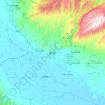
Name: Serres topographic map, elevation, terrain.
Average elevation: 1,040 ft
Minimum elevation: -3 ft
Maximum elevation: 6,401 ft
Make a donation
Gear up for your next adventure:
As an Amazon Associate, this site earns from qualifying purchases at no extra cost to you.
Other topographic maps
Click on a map to view its topography, its elevation and its terrain.
Emmanuel Pappas Municipality
Greece > Macedonia and Thrace > Serres Regional Unit
Average elevation: 1,112 ft