Geolocate

De Pere topographic map

Click on the map to display elevation.

About this map

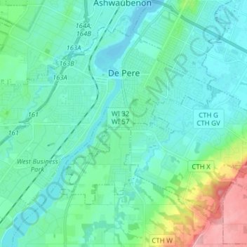
Name: De Pere topographic map, elevation, terrain.

Location: De Pere, Brown County, Wisconsin, 54344, United States (44.39576 -88.14071 44.46612 -88.01375)

Average elevation: 646 ft

Minimum elevation: 577 ft

Maximum elevation: 945 ft

Brown County trails, hiking, mountain biking, running and outdoor activities

Other topographic maps

Click on a map to view its topography, its elevation and its terrain.

Gear up for your next adventure:

🧦Hiking Socks - Comfortable socks to prevent blisters on long hikes
🎒Trail Energy Bars - High‑calorie bars for hiking energy
🔦LED Headlamp - Bright and durable LED headlamp for night navigation
😴Insulated Sleeping Pads - Compact and warm pads for high-elevation camping
🔭Stargazing Telescopes - Perfect for camping in low-light pollution areas shown on maps

As an Amazon Associate, this site earns from qualifying purchases at no extra cost to you.