
Forchheim topographic map
Click on the map to display elevation.
Forchheim
Forchheim (German pronunciation: [ˈfɔʁçhæɪ̯m] ) is a town in Upper Franconia (German: Oberfranken) in northern Bavaria, and also the seat of the administrative district of Forchheim. Forchheim is a former royal city, and is sometimes called the Gateway to the Franconian Switzerland, referring to the region of outstanding natural beauty to the north east of the town. Nowadays Forchheim is most famous for its ten day long beer and music festival (Annafest) which takes place in late July in an idyllic wooded hillside, home to 24 beer gardens, on the outskirts of the town. Forchheim's population, as of December 2013, was 30,705, and its land area is 44.95 square kilometres (17.36 square miles). Its position is 49° 44' N, 11° 04' E and its elevation is 265 metres (869 feet) above sea level.
About this map
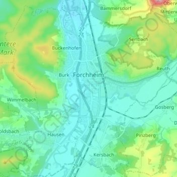
Name: Forchheim topographic map, elevation, terrain.
Location: Forchheim, Landkreis Forchheim, Bavaria, 91301, Germany (49.67385 10.99958 49.75090 11.12663)
Average elevation: 981 ft
Minimum elevation: 820 ft
Maximum elevation: 1,617 ft
Other topographic maps
Click on a map to view its topography, its elevation and its terrain.
Ebermannstadt
Germany > Bavaria > Landkreis Forchheim > Ebermannstadt > Ebermannstadt
Average elevation: 1,339 ft