
Les Replans topographic map
Interactive map
Click on the map to display elevation.
About this map
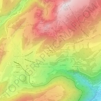
Name: Les Replans topographic map, elevation, terrain.
Average elevation: 3,770 ft
Minimum elevation: 1,929 ft
Maximum elevation: 5,171 ft
Other topographic maps
Click on a map to view its topography, its elevation and its terrain.
Les Praises
Suisse > Vaud > District du Jura-Nord vaudois > Sainte-Croix
Les Praises, Sainte-Croix, District du Jura-Nord vaudois, Vaud, 1450, Suisse
Average elevation: 3,868 ft
La Sagne
Suisse > Vaud > District du Jura-Nord vaudois > Sainte-Croix > La Sagne
La Sagne, Sainte-Croix, District du Jura-Nord vaudois, Vaud, 1450, Suisse
Average elevation: 3,776 ft