
Make a donation
Gear up for your next adventure:
As an Amazon Associate, this site earns from qualifying purchases at no extra cost to you.
Aindling topographic map
Click on the map to display elevation.
Make a donation
Gear up for your next adventure:
As an Amazon Associate, this site earns from qualifying purchases at no extra cost to you.
About this map
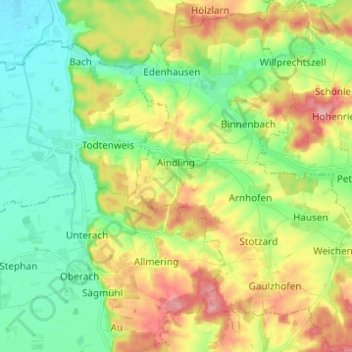
Name: Aindling topographic map, elevation, terrain.
Location: Aindling, Landkreis Aichach-Friedberg, Bavaria, 86447, Germany (48.46814 10.93699 48.54963 11.03448)
Average elevation: 1,555 ft
Minimum elevation: 1,407 ft
Maximum elevation: 1,785 ft
Make a donation
Gear up for your next adventure:
As an Amazon Associate, this site earns from qualifying purchases at no extra cost to you.
Other topographic maps
Click on a map to view its topography, its elevation and its terrain.
Sankt Stephan
Germany > Bavaria > Landkreis Aichach-Friedberg > Sankt Stephan
Average elevation: 1,457 ft
Make a donation
Gear up for your next adventure:
As an Amazon Associate, this site earns from qualifying purchases at no extra cost to you.