
Hastings topographic map
Interactive map
Click on the map to display elevation.
About this map
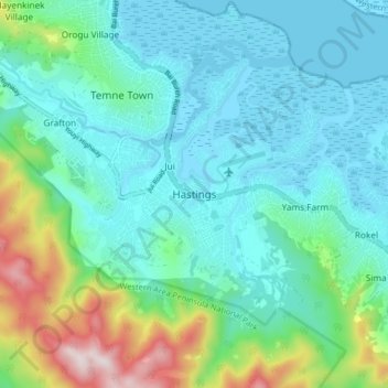
Name: Hastings topographic map, elevation, terrain.
Location: Hastings, Western Area Rural, Western Area, Sierra Leone (8.34730 -13.17872 8.42730 -13.09872)
Average elevation: 482 ft
Minimum elevation: -3 ft
Maximum elevation: 2,254 ft
Other topographic maps
Click on a map to view its topography, its elevation and its terrain.
Waterloo
Sierra Leone > Western Area Rural
Waterloo, Western Area Rural, Western Area, Sierra Leone
Average elevation: 230 ft