
Town of Clark's Harbour topographic map
Interactive map
Click on the map to display elevation.
About this map
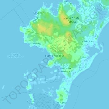
Name: Town of Clark's Harbour topographic map, elevation, terrain.
Average elevation: 7 ft
Minimum elevation: -10 ft
Maximum elevation: 69 ft
Other topographic maps
Click on a map to view its topography, its elevation and its terrain.
Town of Shelburne
Canada > Nova Scotia > Shelburne County
Town of Shelburne, Shelburne County, Nova Scotia, Canada
Average elevation: 92 ft
Stoney Island
Canada > Nova Scotia > Shelburne County
Stoney Island, Municipality of the District of Barrington, Shelburne County, Nova Scotia, B0W 1P0, Canada
Average elevation: 10 ft
Canada Hill
Canada > Nova Scotia > Shelburne County > Canada Hill
Canada Hill, Municipality of the District of Shelburne, Shelburne County, Nova Scotia, B0T 1L0, Canada
Average elevation: 112 ft
Churchover
Canada > Nova Scotia > Shelburne County
Churchover, Municipality of the District of Shelburne, Shelburne County, Nova Scotia, B0T 1W0, Canada
Average elevation: 89 ft
Ingomar
Canada > Nova Scotia > Shelburne County
Ingomar, Municipality of the District of Shelburne, Shelburne County, Nova Scotia, B0T 1W0, Canada
Average elevation: 16 ft
Shelburne
Canada > Nova Scotia > Shelburne County > Shelburne
Shelburne, Town of Shelburne, Shelburne County, Nova Scotia, Canada
Average elevation: 92 ft