
Ives Hollow topographic map
Interactive map
Click on the map to display elevation.
About this map
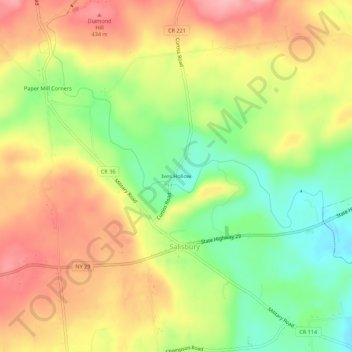
Name: Ives Hollow topographic map, elevation, terrain.
Average elevation: 1,253 ft
Minimum elevation: 1,047 ft
Maximum elevation: 1,440 ft
Other topographic maps
Click on a map to view its topography, its elevation and its terrain.
Paper Mill Corners
United States > New York > Herkimer County > Town of Salisbury
Paper Mill Corners, Town of Salisbury, Herkimer County, New York, United States
Average elevation: 1,335 ft
Salisbury Center
United States > New York > Herkimer County > Town of Salisbury
Salisbury Center, Town of Salisbury, Herkimer County, New York, United States
Average elevation: 1,096 ft
Irondale
United States > New York > Herkimer County > Town of Salisbury
Irondale, Town of Salisbury, Herkimer County, New York, 13454, United States
Average elevation: 1,257 ft
Curtis
United States > New York > Herkimer County > Town of Salisbury
Curtis, Town of Salisbury, Herkimer County, New York, United States
Average elevation: 1,407 ft