
Patalache topographic map
Interactive map
Click on the map to display elevation.
About this map
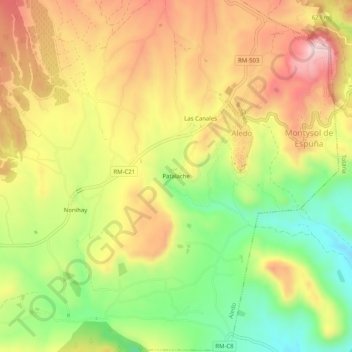
Name: Patalache topographic map, elevation, terrain.
Location: Patalache, Aledo, Bajo Guadalentín, 30859, España (37.77052 -1.60255 37.81052 -1.56255)
Average elevation: 1,860 ft
Minimum elevation: 1,293 ft
Maximum elevation: 2,405 ft
Other topographic maps
Click on a map to view its topography, its elevation and its terrain.
Nonihay
España > Bajo Guadalentín > Aledo
Nonihay, Aledo, Bajo Guadalentín, 30859, España
Average elevation: 1,893 ft