
Make a donation
Gear up for your next adventure:
As an Amazon Associate, this site earns from qualifying purchases at no extra cost to you.
Geneva topographic map
Click on the map to display elevation.
Make a donation
Gear up for your next adventure:
As an Amazon Associate, this site earns from qualifying purchases at no extra cost to you.
Geneva
The altitude of Geneva is 373.6 m (1,225.7 ft) and corresponds to the altitude of the largest of the Pierres du Niton, two large rocks emerging from the lake which date from the last ice age. This rock was chosen by General Guillaume Henri Dufour as the reference point for surveying in Switzerland. The second main river of Geneva is the Arve, which flows into the Rhône just west of the city centre. Mont Blanc can be seen from Geneva and is an hour's drive from the city.
Make a donation
Gear up for your next adventure:
As an Amazon Associate, this site earns from qualifying purchases at no extra cost to you.
About this map
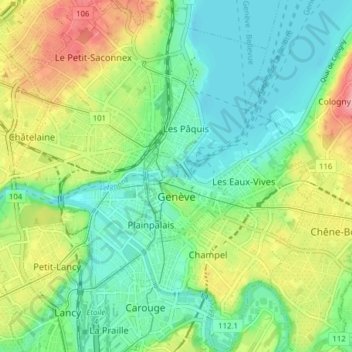
Name: Geneva topographic map, elevation, terrain.
Location: Geneva, Switzerland (46.17777 6.11024 46.23189 6.17585)
Average elevation: 1,325 ft
Minimum elevation: 1,204 ft
Maximum elevation: 1,555 ft
Make a donation
Gear up for your next adventure:
As an Amazon Associate, this site earns from qualifying purchases at no extra cost to you.
Other topographic maps
Click on a map to view its topography, its elevation and its terrain.
Make a donation
Gear up for your next adventure:
As an Amazon Associate, this site earns from qualifying purchases at no extra cost to you.
Make a donation
Gear up for your next adventure:
As an Amazon Associate, this site earns from qualifying purchases at no extra cost to you.
Le Grand-Saconnex
Switzerland > Geneva > Le Grand-Saconnex > Le Grand-Saconnex
Average elevation: 1,358 ft