
Louth topographic map
Interactive map
Click on the map to display elevation.
About this map
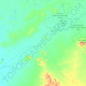
Name: Louth topographic map, elevation, terrain.
Average elevation: 407 ft
Minimum elevation: 279 ft
Maximum elevation: 1,621 ft
Other topographic maps
Click on a map to view its topography, its elevation and its terrain.
Tea Tree Tank
Australia > New South Wales > Bourke Shire Council > Louth
Tea Tree Tank, Louth, Bourke Shire Council, New South Wales, 2840, Australia
Average elevation: 322 ft
Gunderbooka
Australia > New South Wales > Bourke Shire Council > Gunderbooka
Gunderbooka, Bourke Shire Council, New South Wales, 2840, Australia
Average elevation: 472 ft
Yantabulla
Australia > New South Wales > Bourke Shire Council > Yantabulla
Yantabulla, Bourke Shire Council, New South Wales, 2840, Australia
Average elevation: 433 ft
Bourke
Australia > New South Wales > Bourke Shire Council
Bourke, Bourke Shire Council, New South Wales, 2840, Australia
Average elevation: 384 ft