
Saint-Martin-de-Lamps topographic map
Interactive map
Click on the map to display elevation.
About this map
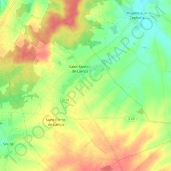
Name: Saint-Martin-de-Lamps topographic map, elevation, terrain.
Average elevation: 492 ft
Minimum elevation: 390 ft
Maximum elevation: 600 ft
Other topographic maps
Click on a map to view its topography, its elevation and its terrain.
Levroux
France > Centre-Val de Loire > Indre > Levroux
Levroux, Châteauroux, Indre, Centre-Val de Loire, France métropolitaine, 36110, France
Average elevation: 528 ft
Les Arènes
France > Centre-Val de Loire > Indre > Levroux
Les Arènes, Levroux, Châteauroux, Indre, Centre-Val de Loire, France métropolitaine, 36110, France
Average elevation: 495 ft