Geolocate

Micanopy topographic map

Click on the map to display elevation.

About this map

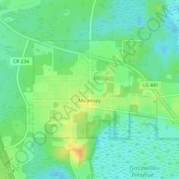
Name: Micanopy topographic map, elevation, terrain.

Location: Micanopy, Alachua County, Florida, United States (29.49882 -82.29127 29.51355 -82.26792)

Average elevation: 98 ft

Minimum elevation: 59 ft

Maximum elevation: 157 ft

Other topographic maps

Click on a map to view its topography, its elevation and its terrain.

Earleton

United States > Florida > Alachua County

Average elevation: 151 ft

Island Grove

United States > Florida > Alachua County

Average elevation: 59 ft

Lakeview Estates

United States > Florida > Alachua County

Average elevation: 115 ft

Misty Oaks

United States > Florida > Alachua County

Average elevation: 69 ft

Bland

United States > Florida > Alachua County

Average elevation: 144 ft

Archer

United States > Florida > Alachua County > Archer

Average elevation: 82 ft

Gear up for your next adventure:

👟Trail Running Shoes - Lightweight shoes for trail runners
🧣Merino Neck Gaiters - Multi-functional headwear for wind and sun protection
🧥Waterproof Jacket for Hiking - Breathable and rugged rain jacket for outdoor excursions
📱Solar Portable Charger - Solar power bank for charging devices off‑grid
🔭Stargazing Telescopes - Perfect for camping in low-light pollution areas shown on maps

As an Amazon Associate, this site earns from qualifying purchases at no extra cost to you.