
Travancinha topographic map
Interactive map
Click on the map to display elevation.
About this map
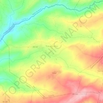
Name: Travancinha topographic map, elevation, terrain.
Location: Travancinha, Seia, Guarda, 6270-605, Portugal (40.40322 -7.84923 40.44146 -7.79428)
Average elevation: 1,266 ft
Minimum elevation: 925 ft
Maximum elevation: 1,608 ft
Other topographic maps
Click on a map to view its topography, its elevation and its terrain.
Sazes da Beira
Sazes da Beira, Seia, Guarda, Portugal
Average elevation: 2,513 ft
Carragozela
Carragozela, Seia, Guarda, 6270-584, Portugal
Average elevation: 1,555 ft
Serra da Estrela
Serra da Estrela, Seia, Guarda, Portugal
Average elevation: 5,988 ft