
Mont Robin topographic map
Interactive map
Click on the map to display elevation.
About this map
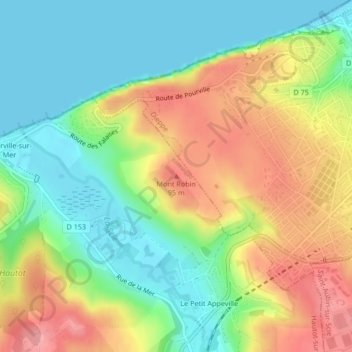
Name: Mont Robin topographic map, elevation, terrain.
Average elevation: 144 ft
Minimum elevation: 0 ft
Maximum elevation: 338 ft
Other topographic maps
Click on a map to view its topography, its elevation and its terrain.
Pourville-sur-Mer
France > Normandie > Seine-Maritime > Hautot-sur-Mer
Pourville-sur-Mer, Hautot-sur-Mer, Dieppe, Seine-Maritime, Normandie, France métropolitaine, 76550, France
Average elevation: 115 ft