
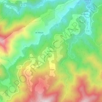
Le Baraga topographic map
Interactive map
Click on the map to display elevation.
About this map
Name: Le Baraga topographic map, elevation, terrain.
Average elevation: 2,595 ft
Minimum elevation: 1,591 ft
Maximum elevation: 4,016 ft
Other topographic maps
Click on a map to view its topography, its elevation and its terrain.
els Cazals
France > Occitanie > Pyrénées-Orientales > Serralongue
els Cazals, Serralongue, Céret, Pyrénées-Orientales, Occitanie, France métropolitaine, 66230, France
Average elevation: 2,238 ft
La Forge de Galdarès
France > Occitanie > Pyrénées-Orientales > Serralongue
La Forge de Galdarès, Serralongue, Céret, Pyrénées-Orientales, Occitanie, France métropolitaine, 66230, France
Average elevation: 2,201 ft
La Badie
France > Occitanie > Pyrénées-Orientales > Serralongue > La Badie
La Badie, Serralongue, Céret, Pyrénées-Orientales, Occitanie, France métropolitaine, 66230, France
Average elevation: 2,641 ft
Fornells
France > Occitanie > Pyrénées-Orientales > Serralongue
Fornells, Serralongue, Céret, Pyrénées-Orientales, Occitanie, France métropolitaine, 66230, France
Average elevation: 2,874 ft