
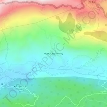
Muttukadu colony topographic map
Interactive map
Click on the map to display elevation.
About this map
Name: Muttukadu colony topographic map, elevation, terrain.
Location: Muttukadu colony, Udumbanchola, Idukki District, Kerala, India (9.99771 77.12109 10.03771 77.16109)
Average elevation: 3,914 ft
Minimum elevation: 2,992 ft
Maximum elevation: 5,820 ft
Other topographic maps
Click on a map to view its topography, its elevation and its terrain.
Santhanpara
India > Kerala > Udumbanchola > Choondal
Santhanpara, Choondal, Udumbanchola, Idukki District, Kerala, India
Average elevation: 3,645 ft
Poopara
India > Kerala > Udumbanchola
Poopara, Udumbanchola, Idukki District, Kerala, 685619, India
Average elevation: 3,740 ft
Murikkumthotti
India > Kerala > Udumbanchola
Murikkumthotti, Udumbanchola, Idukki District, Kerala, 685619, India
Average elevation: 3,606 ft
Rajakkad
India > Kerala > Udumbanchola > Kalungu City
Rajakkad, Kalungu City, Udumbanchola, Idukki District, Kerala, 685566, India
Average elevation: 2,805 ft
Rajakumari
India > Kerala > Udumbanchola
Rajakumari, Udumbanchola, Idukki District, Kerala, 685619, India
Average elevation: 3,284 ft
7th Mile
India > Kerala > Udumbanchola > Anakkara
7th Mile, Anakkara, Udumbanchola, Idukki District, Kerala, 685509, India
Average elevation: 3,658 ft
Thondimala
India > Kerala > Udumbanchola > Poopara
Thondimala, Poopara, Udumbanchola, Idukki District, Kerala, India
Average elevation: 4,560 ft
Anakkara
India > Kerala > Udumbanchola
Anakkara, Udumbanchola, Idukki District, Kerala, India
Average elevation: 3,445 ft