
Place du Maréchal Leclerc topographic map
Interactive map
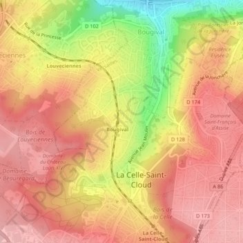
Click on the map to display elevation.
About this map
Name: Place du Maréchal Leclerc topographic map, elevation, terrain.
Average elevation: 423 ft
Minimum elevation: 89 ft
Maximum elevation: 591 ft
Other topographic maps
Click on a map to view its topography, its elevation and its terrain.
Château de la Celle
France > Île-de-France > Yvelines > La Celle-Saint-Cloud
Château de la Celle, Avenue Charles de Gaulle, La Celle-Saint-Cloud, Versailles, Yvelines, Île-de-France, France métropolitaine, 78170, France
Average elevation: 443 ft