
Puerto Lumbreras topographic map
Interactive map
Click on the map to display elevation.
About this map
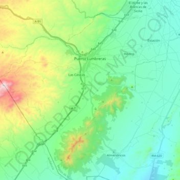
Name: Puerto Lumbreras topographic map, elevation, terrain.
Location: Puerto Lumbreras, Alto Guadalentín, 30890, Spagna (37.46072 -1.91642 37.60636 -1.70158)
Average elevation: 1,578 ft
Minimum elevation: 758 ft
Maximum elevation: 4,068 ft
Other topographic maps
Click on a map to view its topography, its elevation and its terrain.