
Thank you for supporting this site ❤️
Make a donation
Make a donation
Gear up for your next adventure:
As an Amazon Associate, this site earns from qualifying purchases at no extra cost to you.
Ried im Zillertal topographic map
Click on the map to display elevation.
Thank you for supporting this site ❤️
Make a donation
Make a donation
Gear up for your next adventure:
As an Amazon Associate, this site earns from qualifying purchases at no extra cost to you.
About this map
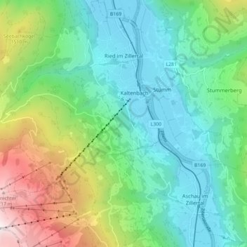
Name: Ried im Zillertal topographic map, elevation, terrain.
Location: Ried im Zillertal, Bezirk Schwaz, Tyrol, 6273, Austria (47.25371 11.80225 47.31302 11.87619)
Average elevation: 3,406 ft
Minimum elevation: 1,772 ft
Maximum elevation: 7,625 ft
Thank you for supporting this site ❤️
Make a donation
Make a donation
Gear up for your next adventure:
As an Amazon Associate, this site earns from qualifying purchases at no extra cost to you.