
Make a donation
Gear up for your next adventure:
As an Amazon Associate, this site earns from qualifying purchases at no extra cost to you.
Dents du Midi topographic map
Click on the map to display elevation.
Make a donation
Gear up for your next adventure:
As an Amazon Associate, this site earns from qualifying purchases at no extra cost to you.
Dents du Midi
The Dents du Midi are situated on the border between the communes of Val-d'Illiez and Evionnaz. The north face rises above the Val d'Illiez while the south face overlooks the Lac de Salanfe, an artificial reservoir. The ridge of the chain is situated at an altitude varying between 2,997 and 3,258 meters (9,833 and 10,689 ft); it is visible from Montreux, 30 kilometers (19 mi) to the north, as well as from the whole of the Rhône plain of the Chablais vaudois. The Dents du Midi are oriented along an axis running from north-east to south-east over a length of 3 kilometers (1.9 mi).
Make a donation
Gear up for your next adventure:
As an Amazon Associate, this site earns from qualifying purchases at no extra cost to you.
About this map
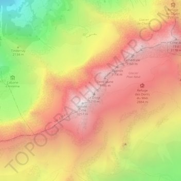
Name: Dents du Midi topographic map, elevation, terrain.
Location: Dents du Midi, Val-d'Illiez, Monthey, Wallis, 1873, Switzerland (46.15246 6.90218 46.17431 6.95053)
Average elevation: 8,005 ft
Minimum elevation: 4,275 ft
Maximum elevation: 10,666 ft
Make a donation
Gear up for your next adventure:
As an Amazon Associate, this site earns from qualifying purchases at no extra cost to you.