
Falmer topographic map
Interactive map
Click on the map to display elevation.
About this map
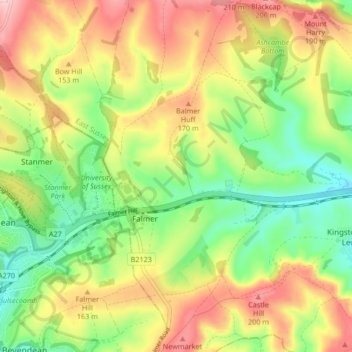
Name: Falmer topographic map, elevation, terrain.
Location: Falmer, Lewes, East Sussex, England, United Kingdom (50.84582 -0.12433 50.89172 -0.04069)
Average elevation: 381 ft
Minimum elevation: 85 ft
Maximum elevation: 738 ft
Other topographic maps
Click on a map to view its topography, its elevation and its terrain.
Plumpton Green
United Kingdom > England > East Sussex > Lewes
Plumpton Green, Lewes, East Sussex, England, BN7 3BU, United Kingdom
Average elevation: 148 ft
Norton Pond
United Kingdom > England > East Sussex > Lewes > Mount Pleasant
Norton Pond, South Heighton, Mount Pleasant, Lewes, East Sussex, England, United Kingdom
Average elevation: 138 ft
Chailey
United Kingdom > England > East Sussex > Lewes
Chailey, Lewes, East Sussex, South East England, England, United Kingdom
Average elevation: 131 ft