
Make a donation
Gear up for your next adventure:
As an Amazon Associate, this site earns from qualifying purchases at no extra cost to you.
Poznań topographic map
Click on the map to display elevation.
Make a donation
Gear up for your next adventure:
As an Amazon Associate, this site earns from qualifying purchases at no extra cost to you.
Poznań
Poznań covers an area of 261.3 km2 (100.9 sq mi), and has coordinates in the range 52°17'34''–52°30'27''N, 16°44'08''–17°04'28''E. Its highest point, with an altitude of 157 m (515 ft), is the summit of Morasko hill within the Morasko meteorite nature reserve in the north of the city. The lowest altitude is 60 m (197 ft), in the Warta valley.
Make a donation
Gear up for your next adventure:
As an Amazon Associate, this site earns from qualifying purchases at no extra cost to you.
About this map
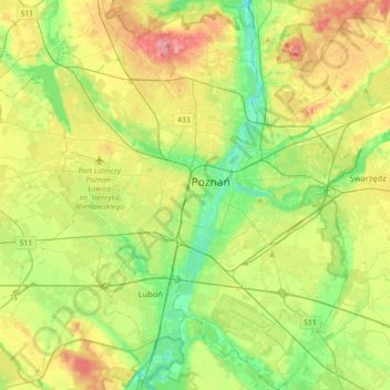
Name: Poznań topographic map, elevation, terrain.
Location: Poznań, Poznań County, Greater Poland Voivodeship, Poland (52.29192 16.73159 52.50933 17.07171)
Average elevation: 279 ft
Minimum elevation: 148 ft
Maximum elevation: 479 ft
Make a donation
Gear up for your next adventure:
As an Amazon Associate, this site earns from qualifying purchases at no extra cost to you.