
Make a donation
Gear up for your next adventure:
As an Amazon Associate, this site earns from qualifying purchases at no extra cost to you.
Cadillac topographic map
Click on the map to display elevation.
Make a donation
Gear up for your next adventure:
As an Amazon Associate, this site earns from qualifying purchases at no extra cost to you.
About this map
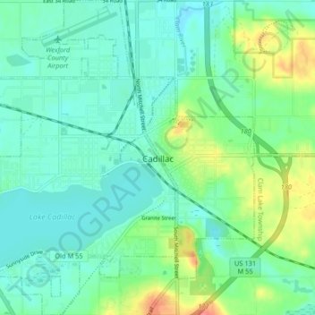
Name: Cadillac topographic map, elevation, terrain.
Location: Cadillac, Wexford County, Michigan, United States (44.22290 -85.45686 44.28128 -85.33598)
Average elevation: 1,329 ft
Minimum elevation: 1,253 ft
Maximum elevation: 1,496 ft
Wexford County trails, hiking, mountain biking, running and outdoor activities
Make a donation
Gear up for your next adventure:
As an Amazon Associate, this site earns from qualifying purchases at no extra cost to you.
Other topographic maps
Click on a map to view its topography, its elevation and its terrain.
Lower Peninsula Experimental Forest
United States > Michigan > Wexford County > South Branch Township
Average elevation: 1,030 ft