Geolocate

Imsouane topographic map

Click on the map to display elevation.

About this map
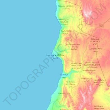
Name: Imsouane topographic map, elevation, terrain.

Location: Imsouane, caïdat de Tamri, cercle d'Agadir-Atlantique, Agadir Ida-Outanane Prefecture, Souss-Massa, 80043, Morocco (30.75102 -9.83001 30.93814 -9.71559)

Average elevation: 466 ft

Minimum elevation: 0 ft

Maximum elevation: 1,729 ft

Other topographic maps

Click on a map to view its topography, its elevation and its terrain.
Ifraden

Morocco > cercle d'Agadir-Atlantique > Taghazout

Average elevation: 689 ft

Gear up for your next adventure:

🧴Hand Sanitizer - Keep hands clean while hiking
👟Trail Running Shoes - Lightweight shoes for trail runners
🧼Biodegradable Camping Soap - Eco‑friendly soap for outdoor hygiene
🌲Outdoor Survival Books - Best books on survival skills
🔋Rechargeable Batteries - Power up your outdoor devices

As an Amazon Associate, this site earns from qualifying purchases at no extra cost to you.