
Frankford topographic map
Interactive map
Click on the map to display elevation.
About this map
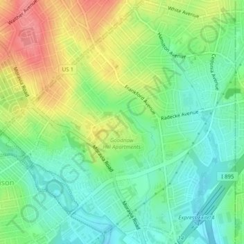
Name: Frankford topographic map, elevation, terrain.
Location: Frankford, Baltimore, Maryland, 21206, United States (39.31407 -76.56321 39.34346 -76.52971)
Average elevation: 131 ft
Minimum elevation: 26 ft
Maximum elevation: 289 ft
Other topographic maps
Click on a map to view its topography, its elevation and its terrain.
Baltimore
United States > Maryland > Baltimore
Baltimore, Maryland, 21233, United States
Average elevation: 213 ft
Middle East
United States > Maryland > Baltimore
Middle East, Baltimore, Maryland, United States
Average elevation: 95 ft
Cedarcroft
United States > Maryland > Baltimore
Cedarcroft, Baltimore, Maryland, United States
Average elevation: 413 ft
Broadway East
United States > Maryland > Baltimore
Broadway East, Baltimore, Maryland, United States
Average elevation: 118 ft
Woodberry
United States > Maryland > Baltimore
Woodberry, Baltimore, Maryland, United States
Average elevation: 308 ft
Saint Josephs
United States > Maryland > Baltimore
Saint Josephs, Baltimore, Maryland, United States
Average elevation: 161 ft