
Ait Ouham topographic map
Interactive map
Click on the map to display elevation.
About this map
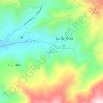
Name: Ait Ouham topographic map, elevation, terrain.
Average elevation: 7,582 ft
Minimum elevation: 6,703 ft
Maximum elevation: 9,085 ft
Other topographic maps
Click on a map to view its topography, its elevation and its terrain.
Ait Bouguemez
Maroc > cercle d'Azilal > Tabant
Ait Bouguemez, Tabant, caïdat de Tabant, cercle d'Azilal, Province d'Azilal, Béni Mellal-Khénifra, Maroc
Average elevation: 6,749 ft
Imélghas
Maroc > cercle d'Azilal > Tabant
Imélghas, Tabant, caïdat de Tabant, cercle d'Azilal, Province d'Azilal, Béni Mellal-Khénifra, 22450, Maroc
Average elevation: 6,509 ft
Valley of the happy people
Maroc > cercle d'Azilal > Tabant
Valley of the happy people, Tabant, caïdat de Tabant, cercle d'Azilal, Province d'Azilal, Béni Mellal-Khénifra, 22452, Maroc
Average elevation: 6,824 ft